Tracing Forest Fires in Indonesia in Recent Years
INFOGRAPHICS
2/5/2026
Indonesia has a vast and diverse landscape, ranging from tropical rainforests to savanna areas. However, the long dry season in this region, coupled with the high intensity of human activity, makes some areas prone to forest and land fires.
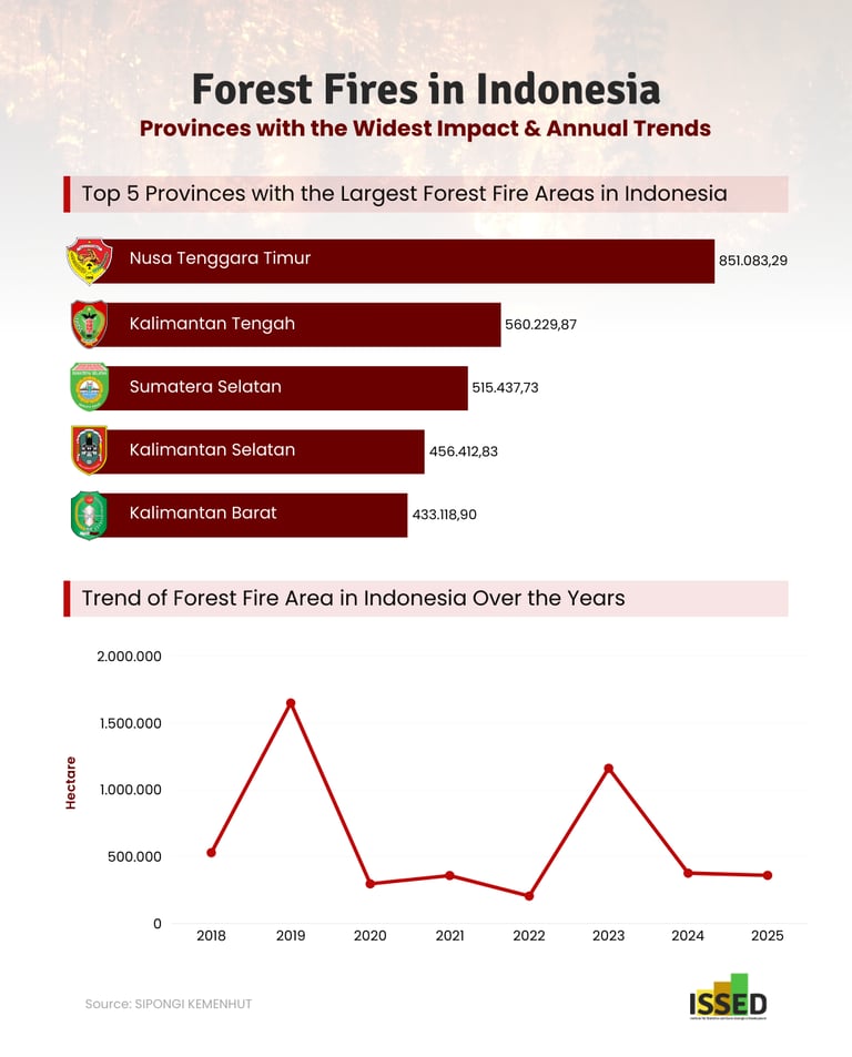
SIPONGI monitoring reports that the number of forest fires in Indonesia has fluctuated during the 2018-2025 period. The peak occurred in 2019, with 1.65 million hectares of land burned to the ground. In fact, the accumulated fires during the monitoring period have reached nearly 5 million hectares. This shows that forest fire prevention policies are not yet fully aligned with climatic conditions and field conditions in Indonesia.
Forest fire prevention policies cannot be generalized across all provinces. Differences in annual climate characteristics, vegetation types, and human activities mean that conditions in each region of Indonesia are not the same. For example, East Nusa Tenggara and South Sumatra are often reported to have the highest rates of forest loss, at around 850 hectares and 515 hectares, respectively. However, the geographical characteristics of these two regions are different, so human activity is also an important factor in forest fires in Indonesia.
The impact of forest fires does not stop at land damage. The smoke produced reduces air quality and increases the risk of health problems for the community. When forests are damaged, the balance of the ecosystem within them is also disrupted, which ultimately causes various losses to living creatures. Therefore, forest damage data is not just a number reported each year, but a reflection of the importance of more appropriate and sustainable forest prevention, restoration, and protection policies